


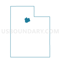
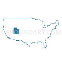
z Unpopulated 8331, Salt Lake County, Utah
About
Outline

Summary
| Unique Area Identifier | 679848 |
| Name | z Unpopulated 8331 |
| County | Salt Lake County |
| State | Utah |
| Area (square miles) | 15.71 |
| Land Area (square miles) | 15.71 |
| Water Area (square miles) | 0.00 |
| % of Land Area | 100.00 |
| % of Water Area | 0.00 |
| Latitude of the Internal Point | 40.61082730 |
| Longtitude of the Internal Point | -112.12673650 |
Maps

Graphs
Select a template below for downloading or customizing gragh for z Unpopulated 8331, Salt Lake County, Utah


Neighbors
Neighoring Voting District (by Name) Neighboring Voting District on the Map
- Voting District 1401, Salt Lake County, UT
- Voting District 3308, Salt Lake County, UT
- Voting District 3456, Salt Lake County, UT
- Voting District 3465, Salt Lake County, UT
- Voting District 3469, Salt Lake County, UT
- Lincoln Voting District, Tooele County, UT
- Stansbury Park 03B Voting District, Tooele County, UT
- z Unpopulated 1104, Salt Lake County, UT
- z Unpopulated 3311, Salt Lake County, UT
Top 10 Neighboring County Subdivision (by Population) Neighboring County Subdivision on the Map
- Salt Lake City CCD, Salt Lake County, UT (932,320)
- Bingham CCD, Salt Lake County, UT (55,288)
- Tooele-Grantsville CCD, Tooele County, UT (54,800)
- Magna CCD, Salt Lake County, UT (28,712)
Top 10 Neighboring Place (by Population) Neighboring Place on the Map
Top 10 Neighboring Unified School District (by Population) Neighboring Unified School District on the Map
- Granite School District, UT (385,194)
- Jordan School District, UT (218,793)
- Tooele School District, UT (58,218)
Top 10 Neighboring State Legislative District Lower Chamber (by Population) Neighboring State Legislative District Lower Chamber on the Map
- State House District 50, UT (54,430)
- State House District 42, UT (51,909)
- State House District 21, UT (44,298)
- State House District 22, UT (40,669)
Top 10 Neighboring State Legislative District Upper Chamber (by Population) Neighboring State Legislative District Upper Chamber on the Map
- State Senate District 10, UT (122,731)
- State Senate District 12, UT (103,070)
- State Senate District 6, UT (94,697)
- State Senate District 24, UT (85,639)
Top 10 Neighboring 111th Congressional District (by Population) Neighboring 111th Congressional District on the Map
Top 10 Neighboring Census Tract (by Population) Neighboring Census Tract on the Map
- Census Tract 1135.34, Salt Lake County, UT (7,303)
- Census Tract 1135.35, Salt Lake County, UT (7,020)
- Census Tract 1139.07, Salt Lake County, UT (6,838)
- Census Tract 1131.05, Salt Lake County, UT (4,235)
- Census Tract 1307.01, Tooele County, UT (3,336)
Top 10 Neighboring 5-Digit ZIP Code Tabulation Area (by Population) Neighboring 5-Digit ZIP Code Tabulation Area on the Map
- 84118, UT (68,295)
- 84074, UT (44,310)
- 84081, UT (40,732)
- 84096, UT (33,396)
- 84044, UT (26,524)
- 84006, UT (826)